Pierce County Critical Areas: What They Are, Why They Matter, and Why 2026 Is Different
TLDR: Critical areas in Pierce County — wetlands, steep slopes, landslide hazards, aquifer recharge zones — don't automatically kill a project. But finding them late does. The county is more backlogged than it's ever been, informal access to planners is gone, and the process has more steps than it did even a few years ago. Here's what you need to know before you buy or build.
What Are Critical Areas?
Pierce County designates certain land conditions as critical areas. Wetlands, steep slopes, landslide hazard zones, erosion hazards, aquifer recharge areas. If your property overlaps with one, it doesn't mean you can't build. It means you need to understand what you're dealing with before you commit. Whether you’re in an R10 Zone, in the Gig Harbor Community Plan overlay, or any other zone in Pierce County, this article is relevant to you if you’re building or remodeling.
Most people find out about critical areas in one of two ways. Either someone looks before they buy, or they run into it head on at permit submittal. Can you imagine which one is where projects get expensive?
Wetlands Are the Biggest Complication in This Region
In an area with as much septic and well infrastructure as the South Sound, wetlands create a specific problem that goes beyond setbacks.
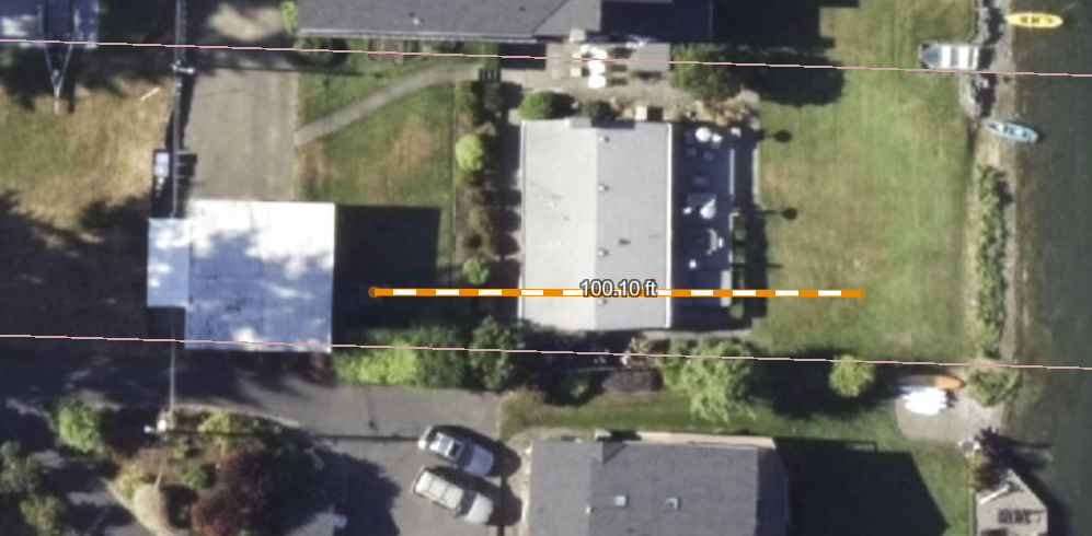
I measured the well-to-septic distance as part of this Gig Harbor waterfront Site Validation.
You can't place a septic system in a wetland buffer. You can't place a well there either. When those two constraints stack on top of a building setback, you can lose a significant portion of what looked like buildable land on paper. Three of the most critical components of any residential development. The building footprint, the septic field, and the well; all restricted from the same area simultaneously.
On Fox Island and the Key Peninsula, wetlands aren't rare. You can’t just look at a property and tell. Wetlands aren’t restricted to just swampy marshes around here. A lot of parcels have them. The question isn't whether they're present; it's where they sit relative to where you need to build and whether the person looking at your plans sees a problem or a design problem to solve.
The GIS Map Is a Starting Point, Not a Conclusive Answer
Pierce County flags critical areas on GIS maps. If you can figure out which filters to turn on and off, you may see them all. When clients pull those maps themselves, they sometimes panic. Or worse, they don't pull them at all. What in the world is an Aquifer Recharge Area anyway, right? (we’ll get to it in a minute)
A flag on a GIS map triggers further review. It isn't an automatic restriction.
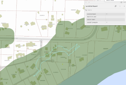
A Site Validation client’s property was in this landslide zone
I had a client with a high bank parcel — not waterfront, but sitting above land with erosion and landslide hazards between it and the water. The GIS marked it as both. I brought it to the county planning department before the client closed on the property. The planner who took the call happened to know that specific area well. He determined that while part of the parcel was flagged, the building site was far enough back that they wouldn't enforce the landslide restrictions there.
That conversation happened during feasibility. It changed everything about how the client understood what they were buying.
What "Flagged" Actually Means in Practice
The aquifer recharge area designation is a useful example. There's a relatively new ordinance that limits impervious surface on affected lots to 10%. Some properties already exceed that limit before any new construction begins. On paper, that looks like a hard stop.
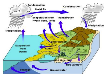
The Hydrologic Cycle, courtesy WA Department of Ecology
It isn't always. The size of what you're proposing makes all the difference. The soil conditions matter. Where a slope sits relative to where you're building matters. On one recent project, eight feet of sand beneath the site meant infiltration was already happening naturally — a condition that changed how the county read the impervious limit entirely. On another, the proposed addition was far enough from a 40% slope that landslide requirements didn't apply at all.
These aren't loopholes. They're how the code actually gets applied to a specific parcel. A planner or engineer who knows the area can tell you which conditions apply to yours. That conversation doesn't happen automatically. Someone has to ask the right questions. Otherwise, you’ll be fed a document that may look like you can’t build when you can.
What Pre-Application Screenings Actually Do
After a Site Validation, I bring specific questions to a pre-application meeting with the county. That's where the actual determination gets made. Not from the GIS map and not from a general reading of the code, but from a planner looking at a specific parcel.
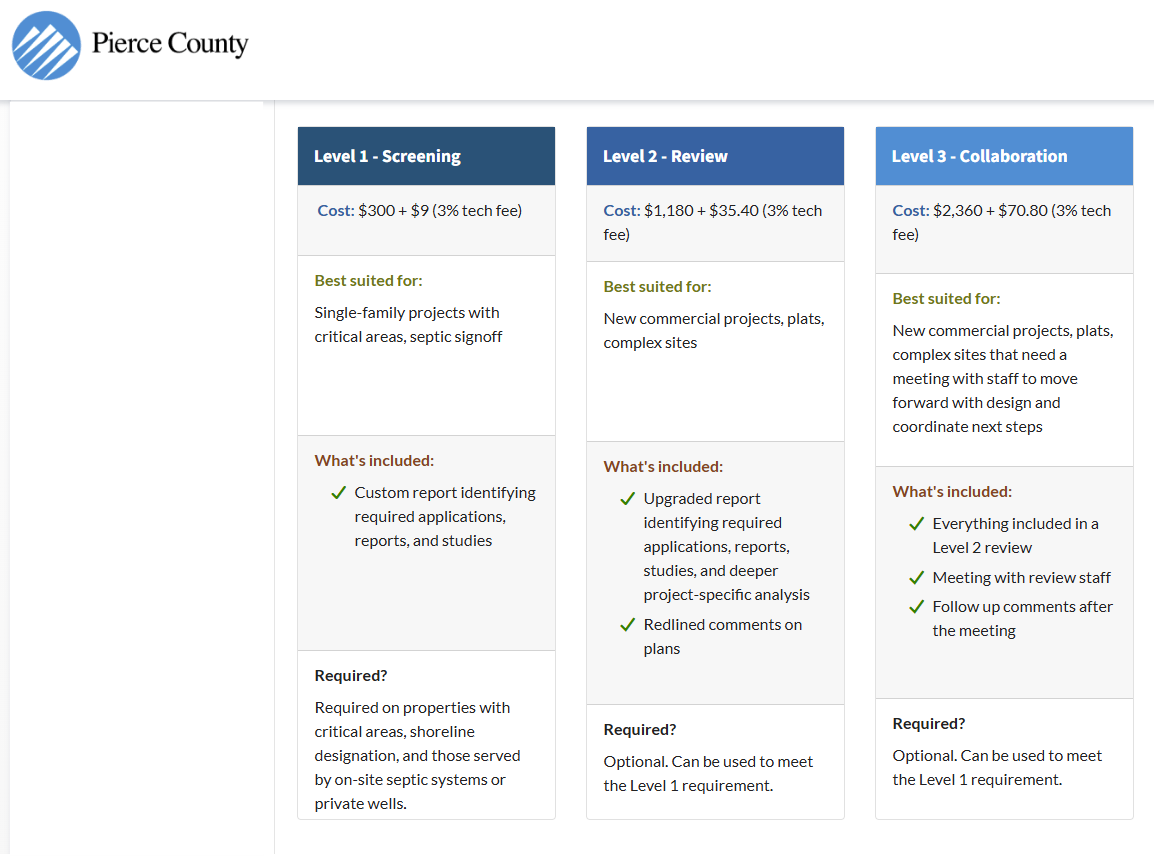
Pierce County Pre-Application Screening Levels - Most single family projects will fall into Level 1
That's the step most people skip, and they can miss out on being pleasantly surprised. They read the map and assume that's the answer. Often it isn't. The county makes real determinations at pre-application, and sometimes things that look like hard restrictions get resolved there. Coming in with pointed questions — ones shaped by what the Site Validation already found — is what makes those meetings productive.
This Has Changed Since 2022
A few years ago, Pierce County planners were accessible in ways they aren't anymore. There was an online chat — you could get a quick answer on a zoning question without scheduling anything. I loved it. I could work on a Site Validation and get official answers in real time. That's gone. They disabled it.
What replaced it is a paid pre-application system. More steps between your question and an answer. And recently (June 2026), Pierce County put out an RFP seeking third-party consultants to help review building plans because their own department can't keep up with volume. I know because they sent me the RFP.
The RFP I got from Pierce County to help get their plans reviewed faster.
They’re under pressure to get projects approved faster. Washington State passed legislation in 2023 requiring counties to issue permit decisions within set timeframes or refund a portion of application fees. The state is pushing for speed. The county is managing volume it wasn't built for. Those two things are happening at the same time.
The timeline between "I'm interested in this parcel" and "I know what I can build on it" has gotten longer, not shorter. Showing up to that process without knowing what you're walking into costs more than it used to.
The informal, figure-it-out-as-you-go access that existed a few years ago is giving way to a more structured process. That's the reality of a region catching up with itself.
What Happens When You Find Out Late
Permit denial is the blunt outcome. The more common version is a six-month stop. You halt the project, hire a wetland ecologist or geotechnical engineer — whoever the county requires — get on their schedule, complete the required investigation or mitigation, and resubmit.
Their schedule, not yours.
The investigation might clear the project. Or it might confirm the restriction. Either way, you're paying for it, waiting for it, and doing it after you've already spent money on design.
Not to mention that investigation will likely require redesign. And when you wait till late to find out, it could mean unraveling everything that the architect, structural engineers, civil engineers, and even interior designers have put together and coordinated.
Critical areas add complexity. They don't always add an insurmountable problem. The difference between a project that navigates them cleanly and one that gets derailed is almost always when the question got asked.
Does your site have flags you haven't looked into yet?